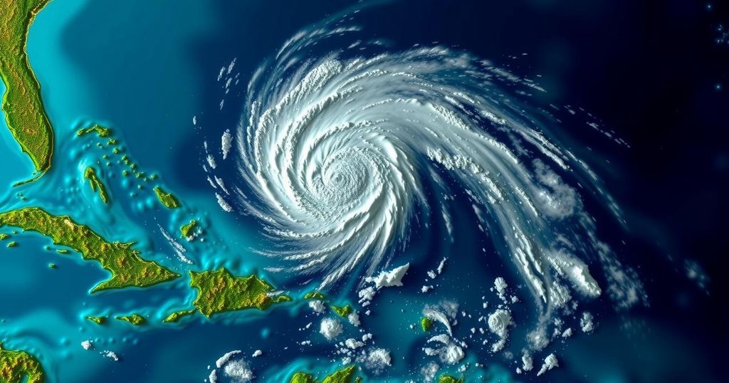
The National Hurricane Center has classified an area of low pressure in the western Caribbean as Potential Tropical Cyclone Eighteen (PTC18), with forecasts indicating the system may develop into a tropical storm and potentially a hurricane by mid-week. A hurricane watch is in effect for the Cayman Islands, while Jamaica is under a tropical storm warning. Milder atmospheric conditions and the historical tendency for storm development in November necessitate ongoing observation as hurricane season draws to a close.
The National Hurricane Center (NHC) has identified a broad area of low pressure in the western Caribbean as Potential Tropical Cyclone Eighteen (PTC18) as of Sunday afternoon. Expectations indicate the low pressure system may evolve into a tropical storm by late Sunday or early Monday, with further intensification anticipated throughout the week. There is the potential for the system to reach hurricane strength by mid-week as it progresses toward the Gulf of Mexico. A hurricane watch has been issued for the Cayman Islands, indicating a possibility of hurricane conditions within a 48-hour timeframe, while Jamaica is under a tropical storm warning, suggesting the likelihood of tropical storm conditions within the next 24 to 36 hours. The NHC predicts the system will drift northwestward over the coming days, potentially bringing heavy rainfall to coastal regions in the western Caribbean. While there is a possibility for the system to enter the Gulf of Mexico later in the week, the evolution of this system may be hindered by adverse weather factors, such as wind shear, dry air, and cooling Gulf waters. Additionally, the NHC is monitoring a trough of low pressure situated near Puerto Rico and Hispaniola, which may lead to localized flooding but has a lower likelihood of developing into a significant storm. A separate system in the Northern Atlantic has been classified as Subtropical Storm Patty, expected to affect the Azores and the Iberian Peninsula with gusty conditions. Historically, the western Caribbean and adjacent regions are known for late-season tropical storm formations, with noteworthy occurrences of named storms in November. Over the last decade, storms have formed in November at sporadic intervals, emphasizing a diminishing likelihood of hurricane activity as the hurricane season approaches its conclusion. Noteworthy past November systems include hurricanes Martin, Nicole, and Lisa in 2022, with Nicole making landfall in Florida as a Category 1 hurricane, marking a significant event in recent hurricane history.
As the Atlantic hurricane season approaches its conclusion, meteorological analyses suggest a notable uptick in tropical development within specific regions, particularly the western Caribbean and adjacent bays. Analyzing historical data provides insights into typical storm occurrences during November, revealing a baseline frequency whereby a named storm may manifest every one to two years. This periodicity underscores the importance of ongoing monitoring as conditions remain conducive in late-season environments, notwithstanding the various atmospheric challenges that may impede storm survival and intensity.
The atmosphere is being monitored closely as Potential Tropical Cyclone Eighteen (PTC18) develops in the western Caribbean, with potential implications for the Cayman Islands and Jamaica. The possibility exists for this system to escalate into a tropical storm or even a hurricane as it enters the Gulf of Mexico amidst varying atmospheric challenges. Understanding historical trends reinforces the necessity for continuous vigilance throughout the final month of the hurricane season, particularly given the unpredictable nature of tropical storms during this time.
Original Source: weather.com