The National Hurricane Center is monitoring three areas in the Caribbean and Atlantic for potential tropical storm activity, particularly a system with a likelihood of becoming the next named storm, ‘Patty.’ While it may bring heavy rain to the Greater Antilles, significant impacts on Florida are not anticipated. High pressure and cooler waters in the Gulf could limit storm development.
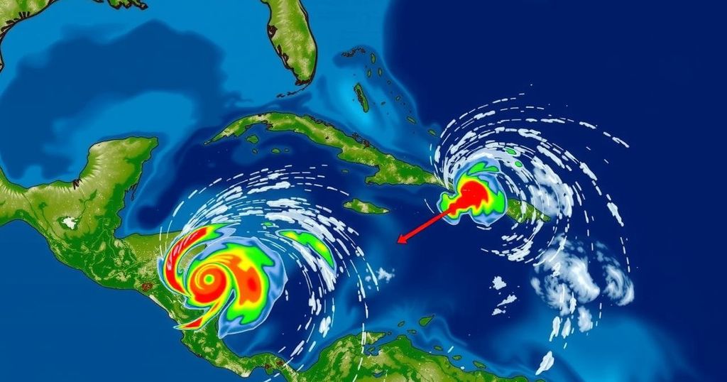
Weather forecasts indicate that three areas are being monitored for potential tropical storm development in the Caribbean and Atlantic regions. Specifically, meteorologists are closely observing a low-pressure system in the Caribbean that may evolve into the next named storm of the Atlantic hurricane season, referred to as “Patty.” Initial predictions suggest that the system, located in the southwestern Caribbean, has a 30 percent probability of developing within the next two days, while this likelihood increases to 70 percent within the next week, according to the National Hurricane Center (NHC). Experts anticipate that a tropical depression or storm could emerge by late this weekend or early next week as the system drifts northward or northwestward through the central or western Caribbean. High atmospheric pressure building in the Atlantic is expected to propel this potential system toward the Gulf of Mexico. As the system progresses, it will likely engage with a new trough of low pressure near Puerto Rico, a feature currently causing widespread showers and thunderstorms across parts of the Greater Antilles and adjacent waters. Although slow development of this new system is plausible as it travels west-northwest near the Greater Antilles, it is projected to produce locally heavy rainfall from the northern Leeward Islands across Puerto Rico, Hispaniola, eastern Cuba, and into the southeastern Bahamas over the next few days. The situation is described by Fox 13 Meteorologist Paul Dellegatto as “a complicated set-up with lots of features to monitor.” The systems moving through the Caribbean will traverse warm water, yet encounter cooler waters upon entering the Gulf, which will influence their intensity. Meteorologist Dave Osterberg remarks, “There’s a much lower heat content than what we had just six to eight weeks ago, so that will make a difference into how all this plays out.” Additionally, high wind shear and drier air in the Gulf region could pose further challenges for these systems. While it is anticipated that the next storm may form within a week, experts have indicated that its potential for significant impact is considerably lower than that of previous storms. Denis Phillips, chief meteorologist for ABC Action News elucidates this perspective, stating, “The way I see it, smaller storms deepen quicker and also weaken quicker.” He notes the rarity of November storms, which may mitigate concerns among the public regarding these developments. Ultimately, forecasters maintain that it is unlikely for the forthcoming systems to have a direct impact on Florida and predict that high pressure will primarily guide the storm’s trajectory westward, potentially affecting the northern Gulf Coast late next week. A separate, non-tropical low-pressure area located approximately 400 miles west of the Azores has emerged, with only a 10 percent chance of subtropical development as it progresses eastward.
The focus on potential tropical storm development stems from the ongoing Atlantic hurricane season, which typically sees various low-pressure systems evolving into tropical depressions or storms. Meteorologists employ predictive models to determine the likelihood of storm formation based on environmental factors such as atmospheric pressure patterns, ocean temperatures, and wind shear. The assessment of development chances provides crucial information for affected regions to prepare for possible weather impacts. In light of the current atmospheric conditions, forecasters study multiple systems, with a specific focus on their trajectories and intensity changes as they move across different sea surface temperatures and wind patterns.
In summary, the National Hurricane Center is monitoring three regions for possible tropical storm development, particularly a system in the southwestern Caribbean that may produce severe weather across various islands in the Greater Antilles. While there remains a likelihood for this system to develop into a named storm, experts believe that significant impacts on Florida are unlikely due to prevailing high pressure patterns. Overall, predictions indicate that while minor developments may be observed, the storms are not expected to escalate to a hurricane level.
Original Source: patch.com