Chances of the low-pressure system AL94 forming into Tropical Storm Nadine have significantly decreased, with current probabilities at 20 percent for the next 48 hours and 30 percent for a week. While it may still impact the northern Caribbean with heavy rain, strong winds are likely to inhibit its development. The NHC continues to monitor the situation as the 2024 Atlantic hurricane season progresses.
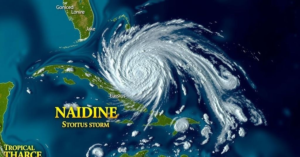
The potential for a low-pressure system in the Atlantic Ocean to develop into Tropical Storm Nadine is diminishing. Monitoring of the system, designated AL94, has been ongoing by the National Hurricane Center (NHC) for several days. This system, which originated off the west coast of Africa, is currently located east of the Leeward Islands and has exhibited fluctuating development probabilities throughout the week. Earlier this week, forecasts indicated a 60 percent chance of development; however, those projections have since decreased to a mere 20 percent for the next 48 hours and a 30 percent chance for the next week. Despite some continuity in the potential for slow development, forecasts indicate that strong winds may ultimately dissipate the system’s viability as the week progresses. According to the latest NHC update, “Showers and thunderstorms associated with a trough of low pressure located a few hundred miles east of the Leeward Islands remain disorganized.” The NHC also noted that as the disturbance advances quickly towards the west-northwest at approximately 20 mph, it is expected to pass close to the Virgin Islands and Puerto Rico on Friday, subsequently affecting Hispaniola and the southeastern Bahamas by Saturday. The influence of strong upper-level winds is anticipated to eliminate any remaining chances of development by the weekend. AccuWeather’s senior meteorologist, Tom Kines, conveyed to Newsweek that the system is likely to bring substantial rainfall and gusty winds to northern Caribbean islands. He remarked, “The chances of this developing into a tropical storm or even a hurricane seem to have diminished over the past couple of days. Having said that, there is still a window that this could develop. If it is going to do it, it must happen in the next two or three days.” It is pertinent to note that the U.S. does not foresee any impact from AL94, which is favorable news for Florida, a state that recently endured two significant hurricanes, Helene and Milton. As of Thursday, there are no active named storm systems prevailing in the Atlantic, although meteorological experts caution that the 2024 Atlantic hurricane season continues, running through November 30. Conditions remain conducive to the formation of hurricanes. Alongside AL94, NHC meteorologists are also monitoring another system in the western Caribbean, which similarly shows low potential for strengthening into a tropical storm. Overall, it appears that potential Tropical Storm Nadine may not develop further, as predicted conditions could inhibit its growth, even though actions to monitor any possibility of development remain vigorous.
Tropical Storm Nadine is a potential weather system currently being monitored by the National Hurricane Center (NHC). It is one of several weather phenomena that arise during the Atlantic hurricane season, which runs until November 30. The chances of tropical storms developing from low-pressure systems in this period fluctuate due to various atmospheric conditions, including wind patterns and water temperatures. Historically, the hurricane season brings a range of tropical storms and hurricanes, necessitating ongoing monitoring by meteorological agencies to predict potential impacts on populated regions, particularly in the Caribbean and along the U.S. coastline. The prospects of storms forming also come with concerns related to heavy rainfall and gusty winds, which can pose hazards even in cases where storms do not fully develop into named systems.
In conclusion, the prospects of the low-pressure system known as AL94 developing into Tropical Storm Nadine have significantly diminished, with current forecasts indicating only a slight chance of formation. Although the system is expected to bring adverse weather, including heavy rain and gusty winds, its potential to strengthen into a tropical storm or hurricane appears limited. Continuous monitoring remains essential, especially with the hurricane season still active through November. Stakeholders in affected regions are advised to stay informed and prepared for any developments.
Original Source: www.newsweek.com